Latest Forecast for Maunakea Observatories
5 PM HST Friday 16 February (0300 UTC Saturday 17 February) 2024

Warnings
Strong winds

Cloud Cover and Precipitation Forecast
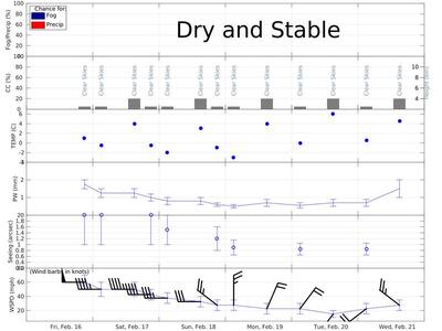
The summit will remain clear, dry and stable through the night.

Summary of Key Meteorological Variables
Summit temperatures will be near 1 C this evening and -0.5 C tomorrow morning. Winds will be from the WSW at 50-70 mph for today, decreasing a tad during the second half of the night. Seeing will exceed 1 arcsecond, while precipitable water is expected to start out near 2 mm, but will subside toward 1 mm by the end of the night.

Graphical Summary

Discussion
A well-defined tradewind inversion will continue to cap low-level moisture at or below 9 thuosand feet and ensure a dry/stable summit-level air mass through the next 5 nights. Daytime clouds will be minimal and short-lived throughout the forecast period.

Skies overhead will remain predominately clear through the next 5 nights.

Precipitable water is expected to briefly increase toward 2 mm for this evening, but will subside as the night progress and through Saturday night, eventually settling in around 0.5-0.65 mm for much of Sunday, Monday and Tuesday night.

Boundary layer turbulence induced by moderate/strong summit winds will contribute to bad seeing through at least Sunday evening. There is a chance for a modest improvement in seeing (toward 0.8-0.9 arcseconds) as summit winds taper toward 20 mph and moderate shear prevails in the free atmosphere for the early part of next week.

No change since the morning forecast...A strong/deep zonal westerly jet will persist to the north and stretch across much of the Pacific, while a rather pronounced mid/surface ridge lingers over or just south of the state into early next week. Nevertheless, the ridge will promote steady large-scale subsidence in the area, which will help maintain a well-defined inversion near primarily 8 thousand feet and ensure a dry/stable summit-level air mass through the next 5 nights. A shallow/weak cold front will continue to pass through over the next 12 hours, eventually falling apart as the weekend progresses. This could result in a brief/subtle increase in PW for tonight and perhaps into tomorrow evening. However, the widespread subsidence combined with very dry post-frontal air should help PW to settle back in near 0.5-0.65 mm for the remainder of the forecast period. Unfortunately, a tight mid/upper-level wind gradient along the southern flank of the front's parent trough will persist overhead resulting in strong winds probably into tomorrow evening. Winds will actually begin to very slowly decline beginning early this evening, but is unlikely to dip below 30 mph until this trough shifts further eastward later in the weekend. Consequently, it is likely that strong boundary layer turbulence will contribute to poor/bad seeing over much of the weekend Models suggest that the westerly jet will split into two (but maintain a stable zonal orientation), while a new tight mid-level ridge develops to the north of the state around Monday. While this will have little to no impact on the stability of the atmosphere, there is a possibility that a relatively tight easterly wind gradient will form over/near the Big Island and prevent summit-level winds from dipping below 20 mph. This will limit seeing from really improving, particularly with building shear in the free atmosphere associated with splitting of the westerly jet for the early part of next week.

Astronomical Observing Quality Guidance
Seeing/CN2 Images are not available today. Sorry for the inconvenience.
Latest WRF CN2 Profiles Animation | Collage


5-day Forecast
Summary

Graphical Trend
08 pm HST
Fri 16 Feb
02 am HST
Sat 17 Feb
02 pm HST
Sat 17 Feb
08 pm HST
Sat 17 Feb
02 am HST
Sun 18 Feb
02 pm HST
Sun 18 Feb
08 pm HST
Sun 18 Feb
02 am HST
Mon 19 Feb
02 pm HST
Mon 19 Feb
02 am HST
Tue 20 Feb
02 pm HST
Tue 20 Feb
02 am HST
Wed 21 Feb
02 pm HST
Wed 21 Feb
06 UTC
Sat 17 Feb
12 UTC
Sat 17 Feb
00 UTC
Sun 18 Feb
06 UTC
Sun 18 Feb
12 UTC
Sun 18 Feb
00 UTC
Mon 19 Feb
06 UTC
Mon 19 Feb
12 UTC
Mon 19 Feb
00 UTC
Tue 20 Feb
12 UTC
Tue 20 Feb
00 UTC
Wed 21 Feb
12 UTC
Wed 21 Feb
00 UTC
Thu 22 Feb
Cloud Cover (%) 0 to 5 0 to 5 0 to 20 0 to 5 0 to 5 0 to 20 0 to 5 0 to 5 0 to 20 0 to 5 0 to 20 0 to 5 0 to 20
Cloud Height (km) above sea level N/A N/A N/A N/A N/A N/A N/A N/A N/A N/A N/A N/A N/A
Chance for Fog/Precip (%) 0/0 0/0 0/0 0/0 0/0 0/0 0/0 0/0 0/0 0/0 0/0 0/0 0/0
PW (mm, summit upward) 1.5 to 2 1 to 1.5 1 to 1.5 0.8 to 1.2 0.6 to 1 0.6 to 1 0.5 to 0.7 0.4 to 0.6 0.5 to 0.9 0.4 to 0.7 0.5 to 0.9 0.5 to 0.9 1 to 2
Mean Seeing (arcsecs) 2.0 ± 1.0 2.0 ± 1.0 N/A 2.0 ± 1.0 1.5 ± 0.5 N/A 1.2 ± 0.4 0.9 ± 0.25 N/A 0.85 ± 0.2 N/A 0.85 ± 0.2 N/A
Summit Temp (°C) 1 -0.5 4 -0.5 -2 3 -1 -3 4 0 6 0.5 4.5
Wind Dir/Speed (mph)
    Summit (615 hPa)
    19,000 ft (500 hPa)
    24,500 ft (400 hPa)
    31,000 ft (300 hPa)
    35,000 ft (250 hPa)
    40,000 ft (200 hPa)
    46,000 ft (150 hPa)
    54,000 ft (100 hPa)

W/50 to 70

W/40 to 60

W/40 to 60

W/35 to 50

W/30 to 45

W/25 to 40

WNW/20 to 35

N/20 to 35

NNE/15 to 30

NE/15 to 30

SW/10 to 20

WSW/15 to 30

WNW/20 to 35


 Rise and Set times for the Sun and Moon
Night (HST)
Sun Set
Twilight End
Twilight Beg
Sun Rise
Moon Rise
Moon Set
Illum (%)
RA
Dec
Fri.Feb.16/Sat.Feb.17
18:31
19:36
5:36
6:41
N/A
1:49
58
4 17.7
25 22
Sat.Feb.17/Sun.Feb.18
18:31
19:36
5:35
6:40
N/A
2:49
68
5 14.9
27 38
Sun.Feb.18/Mon.Feb.19
18:32
19:37
5:35
6:40
N/A
3:45
77
6 12.6
28 23
Mon.Feb.19/Tue.Feb.20
18:32
19:37
5:34
6:39
N/A
4:37
85
7 09.3
27 38
Tue.Feb.20/Wed.Feb.21
18:32
19:37
5:34
6:38
N/A
5:23
91
8 03.9
25 31


Forecast issued by: Ryan Lyman
Contact Us - (808) 932-2323
Hours: Mon-Fri 8 AM - 5 PM HST (1800-0300 UTC)

For public road conditions and snow report message please call (808) 935-6268.
This message is also available at the MKWC road conditions page.

Next update at 10 AM HST (2000 UTC) Tuesday 20 February 2024.
Please call or email to be placed on the Maunakea Weather Bulletin email list.