|
Latest Forecast for Mauna Kea Observatories
Warnings
Cloud Cover and Precipitation Forecast
Summary of Key Meteorological Variables |
Graphical Summary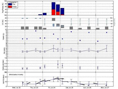
|
|
Discussion |
|
| 05 pm HST Wednesday 22 July (03 UTC Thursday 23 July) | CN2 |
| 08 pm HST Wednesday 22 July (06 UTC Thursday 23 July) | CN2 |
| 11 pm HST Wednesday 22 July (09 UTC Thursday 23 July) | CN2 |
| 02 am HST Thursday 23 July (12 UTC Thursday 23 July) | CN2 |
| 05 am HST Thursday 23 July (15 UTC Thursday 23 July) | CN2 |
| 08 am HST Thursday 23 July (18 UTC Thursday 23 July) | CN2 |
| Latest WRF CN2 Profiles | Animation | Collage |
|
5-day Forecast Summary Graphical Trend |
08 pm HST Wed 22 Jul |
02 am HST Thu 23 Jul |
02 pm HST Thu 23 Jul |
08 pm HST Thu 23 Jul |
02 am HST Fri 24 Jul |
02 pm HST Fri 24 Jul |
08 pm HST Fri 24 Jul |
02 am HST Sat 25 Jul |
02 pm HST Sat 25 Jul |
02 am HST Sun 26 Jul |
02 pm HST Sun 26 Jul |
02 am HST Mon 27 Jul |
02 pm HST Mon 27 Jul |
| 06 UTC Thu 23 Jul |
12 UTC Thu 23 Jul |
00 UTC Fri 24 Jul |
06 UTC Fri 24 Jul |
12 UTC Fri 24 Jul |
00 UTC Sat 25 Jul |
06 UTC Sat 25 Jul |
12 UTC Sat 25 Jul |
00 UTC Sun 26 Jul |
12 UTC Sun 26 Jul |
00 UTC Mon 27 Jul |
12 UTC Mon 27 Jul |
00 UTC Tue 28 Jul |
|
| Cloud Cover (%) | 0 to 20 | 0 to 20 | 0 to 20 | 0 to 20 | 0 to 10 | 60 to 80 | 20 to 40 | 10 to 30 | 0 to 20 | 0 to 10 | 0 to 20 | 0 to 10 | 0 to 20 |
| Cloud Height (km) above sea level | 9.5-10 | 9.5-10 | 9.5-10 | 9.5-10 | N/A | 4-6 | 4-5 | 4-4.5 | N/A | N/A | N/A | N/A | N/A |
| Chance for Fog/Precip (%) | 0/0 | 0/0 | 0/0 | 5/0 | 15/0 | 90/40 | 75/25 | 50/5 | 0/0 | 0/0 | 0/0 | 0/0 | 0/0 |
| PW (mm, summit upward) | 3.5 to 4.5 | 3.5 to 4.5 | 4 to 6 | 3.5 to 4.5 | 3.5 to 4.5 | 4 to 8 | 4 to 6 | 4 to 6 | 4 to 6 | 3.5 to 4.5 | 4 to 6 | 3.5 to 4.5 | 4 to 8 |
| Mean Seeing (arcsecs) | 0.45 ± 0.05 | 0.45 ± 0.05 | N/A | 0.5 ± 0.05 | 0.6 ± 0.1 | N/A | 0.75 ± 0.25 | 0.65 ± 0.15 | N/A | 0.5 ± 0.1 | N/A | 0.5 ± 0.1 | N/A |
| Summit Temp (°C) | 4 | 4 | 9 | 4.5 | 4.5 | 7 | 4 | 4 | 8.5 | 3 | 8 | 2.5 | 8 |
| Wind Dir/Speed (mph) Summit (615 hPa) 19,000 ft (500 hPa) 24,500 ft (400 hPa) 31,000 ft (300 hPa) 35,000 ft (250 hPa) 40,000 ft (200 hPa) 46,000 ft (150 hPa) 54,000 ft (100 hPa) |
N/0 to 10 |
NNE/0 to 10 |
NE/0 to 10 |
NE/5 to 15 |
NE/5 to 15 |
NE/10 to 20 |
ENE/10 to 20 |
E/5 to 15 |
E/5 to 15 |
ESE/0 to 10 |
S/0 to 10 |
WNW/0 to 10 |
S/0 to 10 |
Rise and Set times for the Sun and Moon
Forecast issued by: Ryan Lyman
Contact Us - (808) 932-2323
Hours: Mon-Fri 8 AM - 5 PM HST (1800-0300 UTC)
For public road conditions and snow report message please call (808) 935-6268.
This message is also available at the MKWC road conditions page.
Next update at 10 AM HST (2000 UTC) Thursday 23 July 2015.
Please call or email to be placed on the Mauna Kea Weather Bulletin email list.